


Please also see my web site.
Last week I realised that an historic ferry was running on Brisbane Water during the summer vacation. Brisbane Water is a large, salt water lake that Gosford City is built around the edge of. It empties into the Tasman Sea off the east coast of Australia.
It is named after Sir Thomas MacDougal Brisbane who was Governor of New South Wales from 1821 to 1825.
Gosford City is named after Archibald Acheson, the 2nd Earl of Gosford.
Killcare, where I live and where this journey commences from, is named after an early estate here and simply means come here to Kill your cares.
Reference: www.gosford.nsw.gov.au/library/local_history/placenames.html
Gosford: Believed to have been named after Archibald Acheson, the 2nd Earl of Gosford (1776-1849), with whom N.S.W. Governor Gipps served in Canada.Archibald Acheson was appointed Governor of British North America in 1835.Brisbane Water: Named after Sir Thomas MacDougall Brisbane, Governor of N.S.W. between 1821 and 1825. The naming of Brisbane Water was contemporary with, but not necessarily connected to, the arrival of James Webb, the district's first white settler at The Rip in 1823.
Gosford: Believed to have been named after Archibald Acheson, the 2nd Earl of Gosford (1776-1849), with whom N.S.W. Governor Gipps served in Canada.Archibald Acheson was appointed Governor of British North America in 1835.Brisbane Water: Named after Sir Thomas MacDougall Brisbane, Governor of N.S.W. between 1821 and 1825. The naming of Brisbane Water was contemporary with, but not necessarily connected to, the arrival of James Webb, the district's first white settler at The Rip in 1823.
Killcare: "Killcare estate" was the name given to a 1916 subdivision at Hardy's Bay. The name "Killcare" is a pun, as in "Kill care at Killcare".
So I decided to take Anji on a trip on board the Cockatoo Island Ferry. This happened on Saturday January 9 2010. A beautiful day to be on the water. Clear blue skies, a breeze blowing and many people out enjoying this beautiful water way. It is almost impossible not to be relaxed when you are putting around a large body of water with great weather, great scenery and the sound of the old marine diesel (5 cylinder) putting away softly.
The ferry was built before the second world war and was in service on Sydney Harbour for the Australian Navy. After the war, it was refitted as a passenger ferry to take workers from Circular Quay around to the large ship repair facility on Cockatoo Island. Hence its current name.
Cockatoo Island has been closed as a ship repair point and is now part of the Sydney Harbour National Park. The ferry was purchased by Central Coast Ferries, fully restored and put in to service as a tour boat on Brisbane Water, Gosford.
This is mainly a pictorial with small comments on each or group of photos. I hope you enjoy it.

Coming out of the main channel.

Some of the yachts and cabin boats moored in Hardy's Bay.


Heading out to sea in the main channel before swinging around into the secondary channel for the run up into Ettalong and Brisbane Water.


Leaving Hardy's in the distance behind.
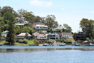
Some of the lucky people who have water views.
 Oyster Leases. There are many on Brisbane Water and the oyster are of high quality.


Approaching The Rip Bridge from south to north.

The Rip Bridge was opened in 1974 and is built across the neck of Brisbane Water. At this point, the main channel is only a couple of hundred metres wide. Being so narrow and having such a large body of water behind it, the in-coming and out-going tides roar through here. creating a very strong current that can stall the most powerful craft, if the skipper is not ready for it. Subsequently, it has become known as "The Rip".
The bridge was built to provide a quicker way to get to the suburbs on the southern-most peninsular on the coast. It is the bottom end of the Central Coast. A major river, the Hawksbury River, exits to the sea here. This river forms the northern border of Sydney and the body of water is called Broken Bay.

St Hubert's Island bridge.
This is an island that was cut up so most people had a water front. Very exclusive. The bridge connects the island to the main land. The ferry passes under this bridge.

Many people share this place for water sports, especially at the weekend.
Here are some that came passed us.

Mum and Dad on a tandem Kayak with kids in tow on rubber dingy.

A fisherman heading home or maybe heading for his favourite fishing spot. This is looking south and The Rip Bridge is in the background

Some people had set up a picnic on a sand bar that has become exposed at low tide. An instant private island.

Two gentlemen have a leisurely sale on a Saturday afternoon in their beautiful old boat.

The Lady Kendall, a larger cruise ferry that cruises the whole of Brisbane Water from the northern end to the entrance at the southern end.


This ferry is the Palm Beach ferry (See blog dated 11 Jan 2010).
It travels across the open waters of Broken Bay and the Tasman Sea from the northern-most part of Sydney, Palm Beach, and stops at two points in Brisbane Water, Ettalong and Wagstaff. It is also a very popular trip of about 30 minutes. Many people who work on the northern beaches of Sydney will even take the early trip across the bay to go to work.
There is also another ferry that travels from Woy Woy to Saratoga. This is the only commuter ferry still running on Brisbane Water.

Economy class fishing boat.


A channel marker that looks a little worn around the base.
 There are many pelicans around Brisbane Water. They can be seen soaring high in the sky, circling on the thermal currents on a warm day. This is the place they rest when they are not enjoying themselves in the air.

An island reserve along the way.

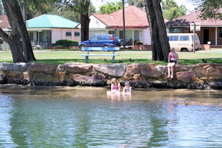
Some kids enjoying the shade of the trees and the cool water on a hot afternoon.

In the channel approaching the destination at Woy Woy.
Coming out of the main channel.
The ferry arriving at Hardy's Bay wharf.

Some of the yachts and cabin boats moored in Hardy's Bay.

Looking across the top of the ferry from under the canopy on the rear deck.

Heading out to sea in the main channel before swinging around into the secondary channel for the run up into Ettalong and Brisbane Water.


Leaving Hardy's in the distance behind.
An older house at Wagstaff Point.

Some of the lucky people who have water views.
 Oyster Leases. There are many on Brisbane Water and the oyster are of high quality.
A pair of locals. Two Oyster Birds who also enjoy Brisbane Water Oysters and other shell fish.
Approaching The Rip Bridge from south to north.

The Rip Bridge was opened in 1974 and is built across the neck of Brisbane Water. At this point, the main channel is only a couple of hundred metres wide. Being so narrow and having such a large body of water behind it, the in-coming and out-going tides roar through here. creating a very strong current that can stall the most powerful craft, if the skipper is not ready for it. Subsequently, it has become known as "The Rip".
The bridge was built to provide a quicker way to get to the suburbs on the southern-most peninsular on the coast. It is the bottom end of the Central Coast. A major river, the Hawksbury River, exits to the sea here. This river forms the northern border of Sydney and the body of water is called Broken Bay.
St Hubert's Island bridge.
This is an island that was cut up so most people had a water front. Very exclusive. The bridge connects the island to the main land. The ferry passes under this bridge.

One of the waterways cut into the island.
Many people share this place for water sports, especially at the weekend.
Here are some that came passed us.
Mum and Dad on a tandem Kayak with kids in tow on rubber dingy.
A fisherman heading home or maybe heading for his favourite fishing spot. This is looking south and The Rip Bridge is in the background
Some people had set up a picnic on a sand bar that has become exposed at low tide. An instant private island.
Two gentlemen have a leisurely sale on a Saturday afternoon in their beautiful old boat.
The Lady Kendall, a larger cruise ferry that cruises the whole of Brisbane Water from the northern end to the entrance at the southern end.
This ferry is the Palm Beach ferry (See blog dated 11 Jan 2010).
It travels across the open waters of Broken Bay and the Tasman Sea from the northern-most part of Sydney, Palm Beach, and stops at two points in Brisbane Water, Ettalong and Wagstaff. It is also a very popular trip of about 30 minutes. Many people who work on the northern beaches of Sydney will even take the early trip across the bay to go to work.
There is also another ferry that travels from Woy Woy to Saratoga. This is the only commuter ferry still running on Brisbane Water.


A channel marker that looks a little worn around the base.
 There are many pelicans around Brisbane Water. They can be seen soaring high in the sky, circling on the thermal currents on a warm day. This is the place they rest when they are not enjoying themselves in the air.
An island reserve along the way.

Some kids enjoying the shade of the trees and the cool water on a hot afternoon.
In the channel approaching the destination at Woy Woy.

The skipper tying up.

Shutting down and going for lunch.

The ferry has a rest.

The beautifully restored inside cabin.

This is Fisherman's Wharf Woy Woy. A fresh sea shop and cafe/restaurant. A great place for lunch. We had an hour here before getting back on the ferry for the trip home.

Into the main channel and heading south towards home.
No comments:
Post a Comment